
The Site
63.5 acres on the south shore.
One irregular parcel of prairie between a county road and Eagle Lake. Here it is as it stands today, what we plan to build on it, and what still has to be confirmed.
- Site access
- 50°58′45″N · 113°19′50″W
- Legal land
- SE 29-23-24-W4
- Area
- 63.5 ac · 25.7 ha
- Municipality
- Wheatland County
- Frontage
- South shore · lake to the north

The parcel
Between the south road and the shore.
SE 29-23-24-W4 is the land lying south of Eagle Lake in the south-east quarter of Section 29. That is the whole site. It fronts the south shore, with the lake to the north.
A road allowance runs along its south edge, and that's where we plan the entrance. A water channel runs along the east edge. It may be the lake's outlet, which the Western Irrigation District (WID) operates, and we're confirming exactly where it runs. Everything 51 North builds sits between that south road and the shore.
The shore itself stays public. Under the County's area plan, a strip along the water is set aside as reserve and park, and in the proposed layout, lots sit at least 100 ft from the shore.
Conceptual plan
How the land is meant to work.
This is a concept, drawn to explain the idea. The real layout, lot sizes and lot count come from the survey, the studies and County approval.
Legend
Point at or select a row to see that layer on its own. Select it again, or press Esc, to show every layer.
 Public shoreline park (open to everyone)
 Public shore pathway
 100-ft setback: in the proposed layout, lots sit south of this line
 Phase 1 lots (zone only; count to be set)
 Later phases (zone only)
 The Commons: lodge, store, firepit, splash pad
 Trails
 Birding boardwalk through the reeds
 Paddle launch (subject to approval)
 WID outlet channel (location TBC)
 51°N across the lake (approx., to be survey-verified)
 Planned entrance from the south road
 Parcel boundary, SE 29-23-24-W4 (approx.)
Lake access, honestly
From the lots to the water.
The shoreline stays public. Here's what the area plan puts between the lots and the lake, and who draws each line. The route from any one lot to the water is still being designed.
Lot area
Proposed, behind a gate at the entrance. The number, size and layout of lots come from the survey and County approval.
Set by: survey · Wheatland County
Shoreline park & pathway
Planned, and open to everyone. The area plan requires at least 15% of the shoreline frontage as public park, plus a pathway along the shore.
Set by: Wheatland County · subject to approval
Environmental reserve
A natural strip at least 6 m wide, measured from the high-water line, and wider where land floods or has habitat value. Public, and left natural.
Set by: County · WID · Alberta Environment
Eagle Lake
Public water. No private docks, launches or marinas. A carry-down paddle launch is planned, subject to approval.
Governed by: Eagle Lake Area Structure Plan
Plain facts
What we know. What we're confirming.
We keep this list current. When something moves from the right column to the left, it moves here first.
What we know
- The site is 63.5 acres on the south shore of Eagle Lake (SE 29-23-24-W4).
- The shoreline stays public: a park and pathway for everyone.
- In the proposed layout, lots sit at least 100 ft back from the shore.
- Walleye and pike are catch-and-release.
- Eagle Lake is part of a globally significant Important Bird & Biodiversity Area.
- It's about an hour from east Calgary and about 30 minutes from Strathmore (estimated without traffic).
What we're confirming
- The final lot count, set by survey and County approval.
- Whether a paddle launch is approved, and where.
- Swimming status and algae monitoring. We link to AHS live advisories.
- Water and wastewater servicing design, with Alberta Environment and AHS.
- Where the WID outlet channel runs along the east edge.
- Final road access, set by a traffic study.
- The timeline. Each step appears on the Progress page as it lands.
Seasons and use
When could you use it?
The lake has four seasons. The camping season is a separate question, and so are winter stays, leaving your RV and storage. Here's where each one stands. We'll update each row as it's confirmed.
Camping season
PlannedWe're planning May to October. Exact opening and closing dates aren't set.
Confirms: Wheatland County · servicing design
Winter stays
Not confirmedWe haven't decided whether overnight stays outside the camping season will be allowed, and the County has to confirm what the land use permits. Please don't plan on it yet.
Confirms: Wheatland County · community rules
Leaving your RV on your lot
Not confirmedWhether an RV can stay on its lot between visits, or over winter, will be set by the community rules and the County's land-use terms.
Confirms: Wheatland County · our lawyer
RV & boat storage
PlannedYear-round storage on site is planned. Its location, size and terms aren't set.
Confirms: the site plan · Wheatland County
Water and wastewater
Not confirmedThe area plan requires communal piped water and wastewater, with no septic fields. Whether the systems run year-round or only in the camping season depends on their design.
Confirms: our engineer · Alberta Environment · AHS
Winter roads
Not confirmedThe last ~8 km are gravel county roads. Who would clear the roads inside the community, and when, isn't decided.
Confirms: Wheatland County · community operations
Emergency access
Not confirmedRoad access, including for emergency vehicles, will be set by a traffic study and County approval.
Confirms: traffic study · Wheatland County
Amenities
What we plan to build.
Everything here is planned. Nothing is built. Anything at the shoreline also needs approval, and it's marked.
Public shoreline park
Lawn, benches and fire rings along the south shore, open to everyone on the lake.
PlannedSubject to approvalShore pathway
A public path along the water, part of a trail the area plan hopes will one day circle the lake.
PlannedSubject to approvalBirding boardwalk
A low boardwalk through the reeds, for fall migration and nesting season.
PlannedSubject to approvalCarry-down paddle launch
A public launch for kayaks and canoes. No private docks or slips.
PlannedSubject to approvalPaddle racks & gear shed
At the top of the shore path, set back from the water.
PlannedSplash pad
Water play for the kids that doesn't depend on the lake.
PlannedThe Lodge
A shared hall at The Commons.
PlannedFirepit commons
A central fire ring and lawn where the day ends. Subject to seasonal fire bans.
PlannedCamp store
Firewood, ice, bait and basics. Local shops are allowed once the area reaches a set size.
PlannedSubject to approvalPlayground
Natural materials.
PlannedOff-leash dog park
Fenced, away from the shore and the nesting birds.
PlannedDark-sky lookout
A low-light viewing area. Site lighting planned to keep the sky dark.
PlannedGated lot roads
Low-speed roads inside the lot area that kids can bike on. The shore stays open to the public.
PlannedFull hookups
Power, water and sewer at each lot, on communal water and wastewater systems approved by Alberta Environment and AHS.
PlannedSubject to approvalRV & boat storage
Year-round storage on site. Location to be set in the plan.
Planned
Getting here
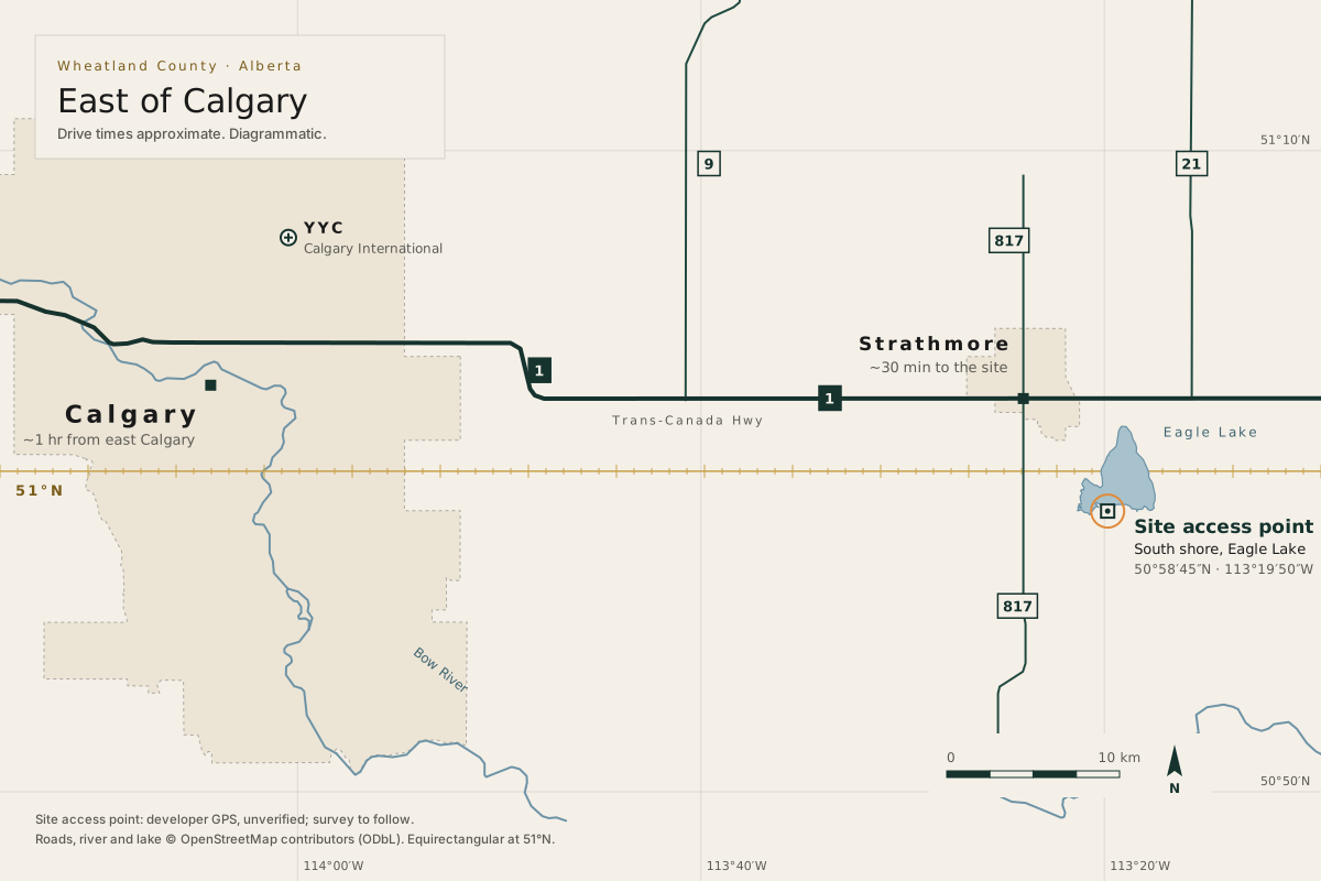
About half an hour from town.
From the Trans-Canada, the last ~8 km are gravel county roads: the road along the south boundary, then Namaka Road or Eagle Lake Road. The final access route will be set by a traffic study, and the area plan moves highway access to Highway 21 over time.
| From | Time | Distance | Relative time |
|---|---|---|---|
| Strathmore | ~30 min | 18 km | |
| East Calgary | ~1 hr | 60 km | |
| Downtown Calgary | ~70 min | 68 km | |
| Calgary airport (YYC) | ~70 min | 69 km | |
| Lethbridge | ~2.5 hr | 175 km | |
| Red Deer | ~2¾ hr | 203 km | |
| Medicine Hat | ~3 hr | 234 km | |
| Edmonton | ~4½ hr | 355 km |
Source: OSRM route estimates (router.project-osrm.org), retrieved 2026-09-26. Real times vary with traffic, weather and road conditions.
Strip diagram: from east Calgary, 60 km and ~1 hr to the site access point; Strathmore is 18 km and ~30 min away; the last ~8 km are gravel county roads.
The Founders List
See it before anyone else does.
Founders hear about every step first. Free to register. No deposits before approvals.